Remote sensing technology reveals the 'flight path' of desert locusts
Since the second half of 2018, desert locusts have gradually swept across the Horn of Africa and countries in Southwest Asia, seriously endangering agricultural production and food security in countries such as Pakistan, Ethiopia, and Somalia. Recently, the Food and Agriculture Organization of the United Nations (FAO) issued a global warning, urging countries to remain vigilant against the rampant locust plague and take joint prevention and control measures to prevent the invasion of pests and serious food crises.
Where do desert locusts come from? Where have you flown over?
Chinese remote sensing experts have been engaged in locust remote sensing monitoring and prediction research for many years. The team mainly uses medium and low resolution satellite images as the main remote sensing data source, combined with ground survey data such as locust invasion and reproduction, land use/cover data, temperature and monsoon data released by FAO, to study the spatiotemporal distribution of desert locust breeding and migration that ravages the Horn of Africa and Southwest Asian countries, as well as the predicted path of locust migration and invasion in the Indian Pakistani border desert in China (see Figure 1).
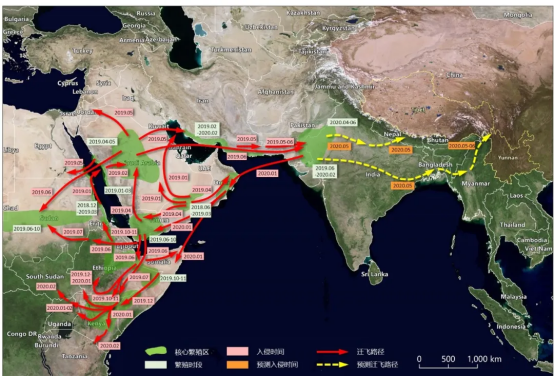
Figure 1. Main migration routes of desert locusts from 2018 to 2020
In 2018, heavy rainfall in the southern Arabian Peninsula provided favorable habitat conditions for the breeding and reproduction of desert locusts. From the above figure, it can be seen that locust swarms from Yemen and Oman began to invade eastern Saudi Arabia and southern Iran in 2019, and then entered southwestern Pakistan from Iran. At the same time, local desert locusts along the India Pakistan border continue to hatch and swarm.
Since January 2020, the locust swarms along the India Pakistan border have started three generations of breeding. Influenced by the northeast monsoon, the swarms will migrate to countries such as Iran and Oman, with a relatively low probability of entering China; But if it is summer, the desert locusts in Pakistan and India still cannot be effectively controlled, and the southwest monsoon in the Indian Ocean is exceptionally strong, there is a risk of them entering our country and threatening our food security. Therefore, China needs to strengthen field pest monitoring and carry out early scientific control.
Integrating multiple technologies to support locust monitoring and early warning
Food security has always been a hot topic of concern for the international community. Against the backdrop of global climate change, the scope and prevalence of pest infestations have shown a clear trend of expansion and enhancement. Locusts are one of the major migratory pests worldwide. For China, the East Asian migratory locust has always been an important factor restricting food security, ecological security, farmers' income increase, and social stability. This year, there are two types of areas in East Asia that need special attention for locusts in China - old locust areas where the frequency of locusts has increased due to changes in locust area and distribution in recent years, and new locust areas formed due to the construction of new reservoirs, water source protection areas, extensive cultivation, and mining area collapses. The main threat in regions such as Africa and Southwest Asia is desert locusts.
The traditional pest visual inspection and manual single point monitoring methods, as well as limited station meteorological data prediction methods, can only obtain pest occurrence information at the "point", which is far from meeting the needs of large-scale and timely pest control on the "surface". Compared with traditional pest field investigation techniques, remote sensing can efficiently and objectively monitor and warn of pest occurrence and development on a large scale, which has important practical significance for efficient scientific prevention and control.
In recent years, the rapid development of Earth observation technology has provided effective technical means for large-scale monitoring and early warning of locusts. A high-frequency, high spatial resolution, multispectral, and fully covered Earth observation system is being constructed using satellite remote sensing data from the domestic GF series, HJ series, MODIS and Landsat TM from the United States, and Sentinel series from the European Space Agency.
In addition, the constantly updated encrypted meteorological station data and the surface meteorological parameter products formed by the coupling of remote sensing and meteorological data provide a richer source of information for monitoring locust habitats (the environment on which locusts rely for living and survival). Currently, the development of multi-source information fusion algorithms helps to fully utilize complementary information in heterogeneous multi-source data, forming spatiotemporal continuous datasets with higher resolution and accuracy. In addition, with the continuous deepening of research on the biological characteristics of locusts, the understanding of their development and diffusion process and environmental influencing factors is constantly improving, which enables the occurrence and development process of locusts to be characterized and simulated through models, providing legal guidance and technical support for the construction of locust monitoring and early warning models.
Chinese research teams have made a lot of work in the field of locust remote sensing monitoring and prediction research over the years. They established a remote sensing monitoring model for pests and diseases based on satellite remote sensing, and achieved large-scale remote sensing monitoring and mapping of pests and diseases; A large-scale prediction model for crop diseases and pests was established by integrating multi-source data from remote sensing, meteorology, crop protection, and other satellite, machine, and ground sources, and organically linking them with the mechanisms of disease and pest outbreaks. The team uses medium to high resolution satellite imagery as the main remote sensing data source, combined with land use/cover data, meteorological data, ground survey data, etc., to quantitatively extract and analyze key factors closely related to the occurrence and distribution of locusts, such as terrain, soil type, soil moisture, surface temperature, vegetation type, vegetation coverage, etc. Based on the characteristics of locust occurrence and development, the team couples pest biological mechanisms and pest occurrence and spread models to carry out remote sensing monitoring and early warning of locust occurrence and development, and analyzes and verifies them with ground survey data.






Please first Loginlater ~