Probing into the Geological Assets of the Ocean with Precision
Probing into the Geological Assets of the Ocean with Precision
Over the course of more than 20 years, China has achieved full coverage of 1:100,000-scale marine regional geological surveys within its jurisdictional seas and is accelerating the progress of 1:25,000-scale marine regional geological surveys - Probing into the Geological Assets of the Ocean with Precision.

Three-Point Positioning in Action
A thriving ocean signifies a thriving country, and a strong ocean signifies a strong country. President Xi Jinping has emphasized that to build a marine power, we must further care for the ocean, understand the ocean, and plan for the ocean, while accelerating the pace of marine scientific and technological innovation.
Today, we have taken a solid step in understanding the ocean. On May 28th, at the First Marine Regional Geological Survey Conference held in Qingdao, Shandong, a systematic set of findings from the 1:100,000-scale marine regional geological survey, which comprehensively reflects the geological, resource, and environmental landscape of China's jurisdictional seas, was officially released to the public. This comprehensive and original series of achievements, covering approximately 3 million square kilometers of China's jurisdictional seas, not only fills the gap in marine regional geological surveys of China's jurisdictional seas but also effectively enhances China's voice in the international marine geosciences community.
Footprints Across China's Seas
1:100,000 Marine Regional Surveys Achieve Full Coverage of Jurisdictional Seas
Marine regional geological surveys serve as the "pathfinder" for marine geological survey work, with a 1:100,000 scale representing the most basic level of detail.
China's marine regional geological survey work started late and from a low base. With the launch of the National Land and Resources Survey in 1999, China initiated a pilot 1:100,000 marine regional geological survey, marking the beginning of marine regional geological surveys within its jurisdictional seas.
"According to international standard mapping, China's 3 million square kilometers of jurisdictional seas can be divided into 20 standard 1:100,000-scale map sheets," introduced Zhang Yong, chief expert of the Marine Basic Geological Survey Project at the China Geological Survey and deputy chief engineer at the Qingdao Institute of Marine Geology. In 1999, the survey work for the demonstration map sheet of the Nantong area at a 1:100,000 scale was initiated, utilizing advanced geological and geophysical survey equipment, testing methods, and analytical instruments to obtain a vast amount of marine geological and geophysical field measurement data, indoor analysis data, and comprehensive research results.
More importantly, through the demonstration map sheet, a unified standard for field surveys, data processing, sample testing and analysis, result map compilation, and report writing was explored, leading to the formulation of the "Specifications for 1:100,000 Marine Regional Geological Surveys," which laid a solid foundation for subsequent comprehensive map sheet surveys.
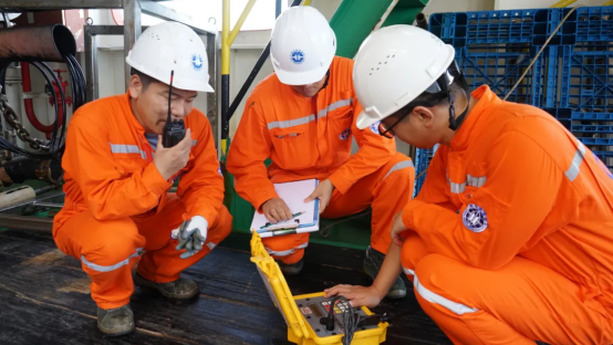
From 2006 to 2015, the 1:100,000 regional geological survey of China's jurisdictional seas was comprehensively carried out. The China Geological Survey organized more than 60 units and over a thousand marine geologists, mobilizing more than 40 survey vessels, over 10 airplanes, and more than 700 survey equipment, leaving footprints across China's seas.
Advanced survey methods such as multibeam, seismic, gravity, magnetic, geological sampling, seabed shallow stratigraphic drilling, and aerial geophysical exploration were used in tandem for integrated shallow-to-medium-to-deep surveys. Based on the vast amount of basic geological data collected, the project team conducted further research on seabed topography and geomorphology, geochemical fields, geophysical fields, fault structures and magmatic activity, deep crustal structures, environmental geological factors, and mineral resources, compiling 120 basic maps, including geological maps, structural maps, topographic maps, geomorphic maps, environmental geological factor maps, and mineral maps, across 20 international standard map sheets, as well as over 300 specialized maps such as geophysical and geochemical series maps, forming approximately 20 million words of marine regional survey reports.
Summarizing Achievements for Further Improvement
Fully Reflecting the Basic Geological Information of China's Jurisdictional Seas
Venturing into the deep blue to understand the ocean. The vast amount of measured geological data obtained from marine regional geological surveys contains the "codes" for understanding the resources, environment, and ecology of the ocean world.
After completing all 20 international standard map sheets at a 1:100,000 scale for marine regional geological surveys, the survey team began integrated research on the vast amount of marine geological, geophysical, geochemical, and remote sensing data collected, systematizing, regularizing, and theorizing it, ultimately forming the first set of comprehensive findings based on measured data that fully reflect the geological conditions of China's jurisdictional seas. These include the first generation of 1:100,000 marine regional geological series maps, the first 1:100,000 marine regional geological database, and the first 1:100,000 marine regional geological report for China's jurisdictional seas. These achievements were officially released to the public at the Marine Regional Geological Survey Conference.
Zhang Yong introduced that based on the implementation of the 1:100,000 marine regional geological survey, a series of original scientific insights were obtained. For example, the innovative theoretical models of "multi-sphere interactions in the East Asian ocean-continent convergence zone" and "back-arc expansion and sinistral shear in the South China Sea" were proposed, reshaping the tectonic framework of the East Asian continental margin. A new scheme for the division of tectonic units in China's marginal seas was established, unifying the Meso-Cenozoic stratigraphic framework of China's seas and improving the classification system of seabed morphologies in China's seas. These new insights have promoted research on fundamental scientific issues in the marginal seas of the Western Pacific.
The 1:100,000 marine regional geological survey also provided basic data and prospecting targets for the new round of strategic actions for mineral exploration breakthroughs. It is understood that this survey delineated eight deepwater oil and gas prospective areas, five deep oil and gas prospective areas, and 40 natural gas hydrate resource prospective areas. Ten locations for iron-manganese nodules (crusts) were newly discovered, and rich rare earth elements were found through rock and mineral analysis. Various types of sea sand resources were discovered, providing important basic geological data support for sea sand exploration.
"The 1:100,000 regional geological survey of China's jurisdictional seas newly discovered and named 780 geographical entities, with 388 approved by the State Council, playing an important role in marine natural resource management. More than 10 sets of natural resource and environmental atlases for major national development strategies were compiled, providing support for the coordinated development of regions such as the Bohai Rim Economic Zone, the Guangdong-Hong Kong-Macao Greater Bay Area, and Hainan Free Trade Port," Zhang Yong introduced. As the foundation for all marine geological work, marine regional geological surveys will provide more important basic data to support energy and resource security, serve ecological civilization construction and natural resource management.
Compared to land, conducting surveys and detections at sea is more challenging due to the covering of seawater, requiring more advanced survey techniques and equipment. Through the implementation of the 1:100,000 marine regional geological survey, 15 technical specifications for marine geological surveys were formed, initially establishing an investigation technology system incorporating "sky, space, land, sea, and wells," with the overall survey capability reaching the international advanced level. "Especially in the coastal transition zone, we applied aerial geophysical exploration surveys and achieved remarkable results," said Zhang Yong.
While advancing the 1:100,000 marine regional geological survey, the project team also completed 1:25,000 marine regional geological surveys for 35 international standard map sheets in key sea areas, accounting for about 15.2% of China's jurisdictional seas, and explored the pilot initiative for 1:50,000 marine regional geological surveys, kicking off the large-scale survey of China's jurisdictional seas.


Please first Loginlater ~