Seeing Temperature with Eyes - Infrared Remote Sensing
Waveband Division and Infrared Remote Sensing
Infrared remote sensing is a technology that uses infrared radiation detection devices to obtain the temperature of a target in a non-contact manner. With infrared remote sensing, humans can "see" temperature without visible light or direct contact. Infrared remote sensing is widely used in military, medical, meteorological, and environmental monitoring fields.
In the military field, infrared remote sensing technology can be used to detect enemy concealed targets, identify and track missiles, etc. In industry, infrared remote sensing can measure the surface temperature of equipment, help engineers detect the operating status of equipment, and identify potential fault points. In medicine, infrared temperature measurement technology can measure body surface temperature, detect fever symptoms, and assist doctors in making preliminary diagnoses. In agriculture, infrared remote sensing can measure land surface temperature and crop temperature, analyze crop growth status and water use. In environmental monitoring, infrared remote sensing can measure atmospheric temperature and water surface temperature, helping scientists understand climate change, marine environments, and land surface changes.
Since infrared remote sensing "sees" the electromagnetic radiation emitted by the target object itself and does not require an auxiliary light source, it can image day and night, enabling night reconnaissance. And compared with radar or lasers, its spontaneous radiation has strong concealment. Infrared cameras, often used to capture the traces of rare wildlife in wildlife protection work, utilize infrared remote sensing.
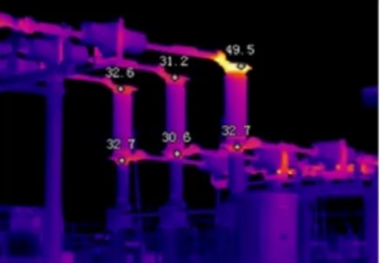
Currently, there are more and more infrared thermal imaging products on the market, which use infrared thermal imaging products to convert the thermal signal of an object into an image recognizable by the human eye. First, the optical system receives and focuses the target's infrared radiation. Then, the infrared detector converts the received infrared radiation into an electrical signal. After a series of signal processing processes such as amplification and filtering, the video data is transmitted to the display for display, and finally, an infrared thermal image corresponding to the surface temperature distribution of the object is obtained.
Correction in Infrared Remote Sensing
Although infrared remote sensing has many advantages in temperature measurement, such as rapidness, high accuracy, and non-contact, it also has some limitations. Measurement results are affected by factors such as ambient temperature, surface reflectivity of the object, and obstacles, and require correction based on specific conditions.
Take atmospheric correction technology in infrared temperature retrieval as an example. Satellites are an important platform for infrared remote sensors, with infrared detection instruments installed on satellites to observe the Earth. Satellites fly at an altitude of several hundred kilometers, separated from the Earth's surface by a thick atmosphere. When designing satellites, atmospheric window bands with higher atmospheric transmittance are usually selected. However, even in the atmospheric window bands, the atmospheric transmittance is not 100%. Components such as water vapor molecules and ozone molecules in the atmosphere absorb infrared radiation, causing the infrared radiation measured by the instrument to be attenuated by the atmosphere. As the concentration of atmospheric water vapor and other gases changes, the transmittance also varies.
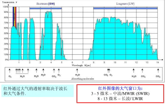
To eliminate the impact of the atmosphere on infrared radiation, researchers have proposed atmospheric correction technology in infrared temperature retrieval to improve the accuracy of surface temperature retrieval. This technology typically includes the following steps:
1.Calculate atmospheric vertical temperature and water vapor profile information through meteorological observation data or models.
2.Calculate the attenuation and emission effects of the atmosphere on infrared radiation through the atmospheric radiation transmission model.
3.Combine the atmospheric radiation effects calculated by the atmospheric radiation transmission model with the atmospheric vertical temperature and water vapor profile information calculated by meteorological observation data or models to calculate the atmospheric correction coefficient.
4.Use the atmospheric correction coefficient to convert the retrieved brightness temperature into surface temperature.
This calculation method is theoretically feasible, but in practical applications, obtaining atmospheric vertical temperature and water vapor profiles is often a challenge. To solve this problem, scientists have invented special algorithms that cleverly utilize the correlation of atmospheric absorption between adjacent observation bands and achieve atmospheric automatic correction by combining observation results from multiple channels. The basic idea of this algorithm is that in the 10-12-micron band, the atmospheric transmittance is correlated with the difference in transmittance between two adjacent bands, which is related to the difference in brightness temperature between the two bands. Therefore, the use of a linear combination of brightness temperatures in two bands can achieve atmospheric correction. This algorithm divides the continuous atmospheric window in the 10-12-micron range into two windows (bands), hence the name "split-window algorithm."
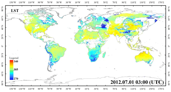
Today, the accuracy of sea surface temperature measured by infrared remote sensing technology on satellites can reach 0.3K, and the accuracy of land surface temperature can also reach 2K. Although human eyes cannot "see" temperature directly like rattlesnakes, with the development of science and technology, we can see more accurate temperatures, larger areas, and a more fascinating world.






Please first Loginlater ~