森林守护卫士的“火眼”
Guardian of Forests: The "Fire Eye"
On March 15th, a forest fire broke out in Baizi Village, Gala Town, Yajiang County, Sichuan Province; on the 16th, due to a sudden increase in wind force at the fire scene, the fire rapidly spread. Over a thousand people affected by the fire were evacuated, and emergency, firefighting, and other departments launched rescue operations... The occurrence of forest fires is characterized by suddenness, great destructiveness, and difficulty in handling and rescue, damaging forest resources and the ecological environment, and bringing tremendous harm and losses to humanity.
Urgent Need for Wildfire Management
Forest resources are one of the important ecological environment resources we rely on for survival. With climate change, the frequency, scale, and duration of global wildfires are increasing, with large forest fires occurring frequently and intensifying. Wildfires severely damage natural ecosystems and increase carbon emissions, becoming a focal issue in global change research.
The fire situation is influenced by the interaction between climate, meteorology, vegetation type, fire sources, and human fire management. Although it is currently difficult to avoid the occurrence of wildfires, their development trend can be controlled through human means to prevent significant damage to humans and natural ecosystems.
"Fire Eye": Wildfire Satellite Monitoring and Early Warning System
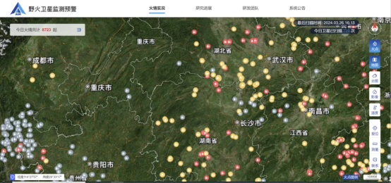
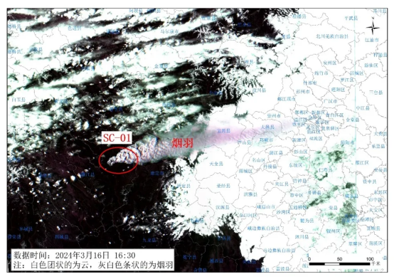
The crucial prerequisite for wildfire management is efficient wildfire monitoring. The Aerospace Information Research Institute of the Chinese Academy of Sciences has independently developed a wildfire satellite monitoring and early warning system based on satellite big data, remote sensing AI algorithms, intelligent fire detection, rapid information dissemination, and other technologies. The system provided timely fire situation and fire potential information for the rescue work of the 3·15 Yajiang mountain fire.
This system integrates methods, models, data, and hardware and software, coupling more than ten satellites to form an open constellation mode to promptly detect wildfires in East Asia, enabling early detection of small fires and continuous tracking of large fires. Additionally, it possesses comprehensive functions such as wildfire risk early warning, spread simulation, post-disaster assessment, and emission accounting, which can be used in emergency management, forestry and grassland administration, environmental protection, electric power, and other application industries, governments, and research institutions. It provides a data basis for grasping the occurrence and development of wildfires, effectively formulating fire fighting strategies and pollution prevention and control measures, and conducting climate change research.
1. Core Functions
·Timely Wildfire Warning: By performing spatio-temporal fusion on data from more than ten polar-orbiting and geostationary satellites, the system fully exploits the advantageous characteristics of each satellite, breaks through a series of key technologies such as precise cloud detection, thermal anomaly inversion, and accurate noise filtering, providing near-real-time and precise monitoring of surface wildfires in the East Asian region.
·Fire Risk Forecast: By integrating satellite remote sensing, atmospheric model simulations, and ground-based observation big data, considering various disaster-inducing and disaster-pregnant factors such as meteorology, phenology, moisture content, topography, and lightning, the system independently develops AI fire risk forecasting technology to issue early warnings for high-risk fire areas, providing data support for the deployment of work in key fire prevention areas.
·Post-Fire Condition Assessment: Through multi-source high-resolution satellite data, the system intelligently detects differences before and after fires to assess post-fire conditions.
·Emissions Accounting of Open Wildfire Burning: With a wildfire emissions dynamic accounting technology that couples multi-source geostationary and polar-orbiting satellite data, the system promptly calculates the emissions of pollutants and greenhouse gases from wildfires, providing important technical and data support for users to assess the impact of wildfires on air quality and formulate control measures.
2. Application Areas
·Forest and Grassland Fire Monitoring and Assessment in Forestry: Applied in forestry and grassland fire prevention management agencies for timely monitoring and early warning of forest and grassland fires, effectively supporting early and small-scale fire fighting to avoid significant fires, especially in unmanned and lightly manned areas, where it is an indispensable fire monitoring and early warning technology. The technology can also be used for post-fire assessments, accurately identifying fire-affected areas and sizes, and calculating vegetation-related losses.
·Timely Monitoring of Major Fires in Emergency Management: Applied in emergency management departments for timely monitoring and progress tracking of various major fires.
·Monitoring of Crop Straw Burning in Agriculture: Applied in agriculture and environmental protection fields for monitoring and control of crop straw burning sites. Users can use near-real-time early warning information on straw fire points to accurately locate and promptly control fire points, avoiding severe air pollution.
·Air Quality Early Warning and Forecasting in Ecological Environment: The monitoring and early warning system provides information on the distribution and duration of wildfire combustion sources to develop dynamic emission inventories of biomass burning pollutants, enabling the air quality early warning and forecasting model to promptly capture dynamic changes in emission sources and contribute to accurate air quality forecasts.
·Timely Monitoring of Mountain Fires in the Power Industry: Used in the power industry for timely monitoring and early warning of mountain fires in areas along power grid transmission lines and facilities to prevent fire development from causing significant economic losses due to damage to power facilities.
·Scientific Research: Used in wildfire-related research, such as fire situations, fire behavior, carbon emissions, climate change, and other scientific research fields.





Please first Loginlater ~