高光谱成像:蚀变矿物填图《多尺度、多传感器数据融合自动三维地质填图》
High-Spectral Imaging: Alteration Mineral Mapping
Multi-Scale, Multi-Sensor Data Fusion for Automatic 3D Geological Mapping
Introduction
High-spectral imaging technology offers a wealth of spectral information, with each pixel corresponding to reflectivity data at different wavelengths. By analyzing these data, different types of minerals can be identified, and their distribution and content can be quantitatively assessed. In the process of mapping, high-spectral imaging aids in determining the spatial extent and distribution of altered minerals, thereby enhancing the understanding of mineralization processes and ore deposit characteristics. Furthermore, when combined with other geological information and data processing methods, such as spectral indices and classification algorithms, more accurate alteration mineral mapping can be achieved. Therefore, high-spectral imaging stands as a potent tool in mineral exploration and geological research.
Mapping the working faces of both opencast mines and underground mines is a crucial task in mining operations, facilitating optimized ore extraction and guiding future exploration efforts. By fusing high-resolution point clouds with high-spectral resolution images to form a "supercloud," both geometric and spectral characteristics can be comprehensively represented, enhancing the ability to infer the often complex chemical, mineralogical, and structural information in natural geological information, thereby generating precise and quantitative geological maps.
Article Overview
This article reconstructs and expands the Mephysto high-spectral toolbox and provides an open-source library, hylite, for correcting high-spectral images, determining imaging positions and camera attitudes relative to high-resolution point clouds, seamlessly back-projecting one or more high-spectral datasets into three-dimensional space, and analyzing the obtained results. Taking the opencast mine at Corta Atalaya in Spain as an example, the article integrates laboratory data, ground images, and UAV high-spectral images to generate a geometrically corrected three-dimensional "supercloud" and applies machine learning methods to analyze the results, generating a structurally complex opencast mine geological map.
Abstract
Using high-spectral reflectance data for attribute-enhanced digital outcrop models, or "superclouds," provides a flexible three-dimensional medium for data-driven geological mapping. This method aids in collecting spatially continuous information about outcrop mineralogy, thereby quantifying mineralization processes, interpreting drilling data, and optimizing mineral extraction. This paper introduces an open-source Python workflow called hylite, which creates superclouds by seamlessly fusing geometric information and data from various high-spectral imaging sensors, applying necessary corrections. Various techniques can be used to analyze these rich datasets, including minimum wavelength mapping and spectral indices, to accurately map geological objects from a distance. Spectral libraries, reference spectra from ground or laboratory measurements can be included to leverage machine learning techniques for supervised classification. By integrating high-spectral data obtained from the laboratory, tripods, and UAVs, the potential of the supercloud method is demonstrated for automatically mapping relevant lithologies and metamorphism associated with volcanogenic massive sulfide mineralization at the Corta Atalaya opencast mine in Spain. These analyses enable quantitative and objective mineral mapping at both outcrop and opencast mine scales, promoting quantitative research and intelligent mining methods. The results highlight the seamless sensor integration achieved by hylite and the powerful capabilities of the data-driven mapping methods applied to superclouds. It is also shown that a random forest (RF) trained solely on labeled sample laboratory data can be used to map appropriately corrected outcrop-scale data.
Main Workflow
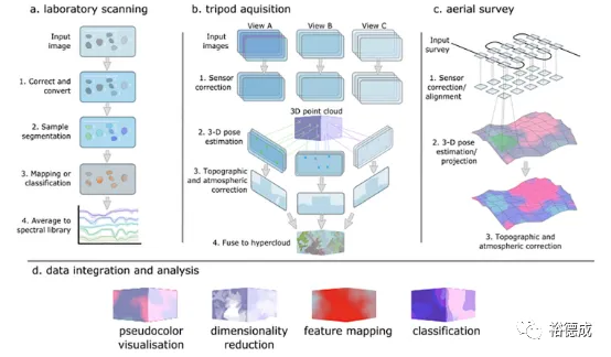
1.Laboratory Scanning: The sisurock-FENIX core scanner was used to collect high-spectral images of 57 representative outcrop samples for creating a spectral library.
2.Tripod Scanning: The FENIX high-spectral camera was mounted on a tripod, and a rotating gimbal was used to obtain panoramic outcrop high-spectral image scans. Complex scenes required data acquisition from multiple overlapping viewpoints to ensure complete coverage.
3.UAV High-Spectral Images: The UAV captured 357 sets of data, which were back-projected onto the point cloud after appropriate corrections.
4.Data Fusion: Spectral data on the horizontal plane mainly originated from Rikola images, while spectral data on the vertical plane mainly came from FENIX images.





请先 登录后发表评论 ~